Guidance devices for the blind
TMB is working to make Barcelona buses and metros accessible to the blind with guidance devices and radio frequency markers.
Following its commitment to accessibility of the Barcelona public transport network , TMB is developing various projects to improve the autonomy of people who are blind or have visual impairment.
As a result of this, from July 2015 two pilot tests are being carried, jointly with the Fundació Vodafone España, the Fundació ONCE and the Fundació TMB, with the collaboration of the Mobile World Capital Barcelona. They consist of a mobile device application and radio frequency markers, to guide people in accessing both the metro and bus.
Alert systems on the metro and bus networks.
In the metro, deployable markers in the installations, interact with an application installed in the user's smart phone, to safely guide users from outside the station to the train.
In buses, once at the bus stop, users automatically receives, in their device, information on vehicles currently at the bus stop, the route number and destination, in order to autonomously decide whether to get on the bus or not. At the same time, the driver is informed that a person who is blind or with visual impairment is at the bus stop.
These technology devices have been tested in real environments, at the Diagonal metro station and a bus stop of the Zona Franca district of the city of Barcelona.
NaviLens, the application for blind people on public transport.
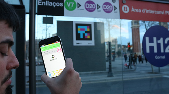
In February 2018, TMB carried out a pilot test of the NaviLens mobile application. As a result of this technology, blind people can read the signage of the public transport networks, both at bus stops and metro stations, and receive accurate guidance through their mobile devices. NaviLens can efficiently capture a new type of QR color codes, called ddTags, so that people with visual disability can read the information contained in this code, without having to know exactly where they are.
At a bus stop, the NaviLens application reads the tag and provides information on the name and code of the stop, the bus routes and destination of each one, the expected time of arrival and any possible disruptions to the service. At a metro station, each area is tagged with a description (access, hall, ticket office, passenger line, stairway, elevator, platform, boarding point...), in order to enable autonomous navigation of people with visual capacity, both at the entrance and exit. This is possible because ddTags can read when moving, at a much higher distance and with a more angular perspective than QR codes, without having to focus the camera of the mobile device.
These projects form part of the TMB universal accessibility Master Plan, which have enabled the introduction of measures to facilitate the mobility of blind people. In the metro, embossed maps of the network and a metro guide in braille have been available since 2012
For more information on accessibility of the bus and metro networks, please consult the web page “Accessibility and reduced mobility”.


